Andes Geo projects and Collaborators

Change detection - Geotechnical Hazard Inventory

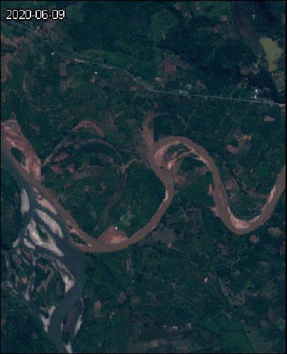
This Project aimed to analyze geomorphological changes along a section of Quijos river in the ecuadorian Amazon. Andes Geo integrated visual interpretation with normalized difference vegetation index (NDVI) and no parametric statistical analysis (Mann-Kendall) to detect geomorphological changes related to landslides and river channel processes following retrogressive landsliding.  

The specific scope of this work included:  

  • – Create a geohazards inventory, including geotechnical and hydrotechnical processes.  
  • – Map geomorphological units and fluvial processes before and after the retrogressive landsliding events. 
  • – Identify and quantify geomorphological change and erosive processes applying geographical information system tools

assessment of mass movements after the occurrence of ETA and IOTA in 2020 in the Protected Forest Zone of El Cajon reservoir, Honduras

The Project consisted of a Rapid assessment of the geohazards and residual risk after the Eta and Iota hurricanes in November 2020. The events affected the Francisco Morazán Hydroelectric Complex (El Cajón). 

The project’s scope included: 

  • – Collecting baseline and historical information 
  • – Preparing a post-event landslide inventory 
  • – Analyzing the precipitation that triggered landslides after and during the storms  
  • – Determining qualitative mass movement risk to prioritize sites for further analysis. 

Remote Monitoring of the Geothermal Exploration Project

The Remote Monitoring Pilot Program was to monitor the progress of the Geothermal Exploration Project located on the southeast slope of the Cosigüina Volcano in western Nicaragua. Andes Geo created a solution to collect, store, and visualize field and remote sensing data.  

The activities included: 

  • – The creation of an intelligent form for field supervisors. 
  • – Collecting and analyzing multi-temporal satellite images throughout the project. 
  • – Organizing the results in the web solution for socialization and interaction.

Geotechnical Hazard Inventory

Assisted Canlin Energy in understanding geotechnical hazards threatening the integrity of their pipelines.  

The main activities included: 

  • – Creating an inventory of mass movements along the pipeline right of way. 
  • – Run machine learning algorithms to generate susceptibility maps 
  • – Prioritizing sites and recommending actions to manage the pipeline’s geotechnical risk. 


.

Geohazard and risk management at Francisco Morazán hydroelectric power plant

The main objective was to identify potential geohazards related to steep-creek processes in the Chilistagüa watershed (a tributary to the El Cajon reservoir). The project focused on modelling clear-water and debris flow events using HEC-RAS for the -10, -20, -50, -100, and -200 years return period. Andes Geo integrated the numerical analysis with a geomorphic assessment to incorporate the potential dynamics related to channel changes (i.e., scour, avulsion, and lateral erosion) following extreme events. The main steps included:  

  • – A geomorphological characterization and identification of the dominant processes within the watershed.  
  • – A detailed shallow landslide inventory using high- and medium-resolution imagery. Andes Geo used the inventory to characterize sediment supply sources, 
  • – A rainfall-runoff analysis using the HEC-HMS framework. 
  • – A numerical model using the HEC-RAS framework.  
  • An assessment of steep creek hazard scenarios. 

ISA Peru

We developed a geohazard management system for ISA Peru. Key deliverables include:

  • – 22,000 towers assessed
  • – 82 Substation assessed
  • – Multi hazard assessment for temperature, precipitation, wind, wildfire, lightning, flood (fluvial, pluvial, coastal), landslides (channeled and open slope)
  • – Climate change scenarios up to 2100

.

Interactive Dashboard

Data are accessible in an interactive dashboard allowing users to quickly access critical information

Early warning system

Weather API allows for early warning and alarm systetm implementation